
Trending Now

You can show almost anything on a map, which is awesome, because people really love visual representations of things – even totally random statistics and facts, like we’re about to show you.
Maybe even especially random statistics and facts, if we’re honest, which means you’re going to love these!
18. Tree Diversity.
I just love trees, y’all.
17. How America Utilizes Its Land.
Sort of eye-opening, isn’t it?
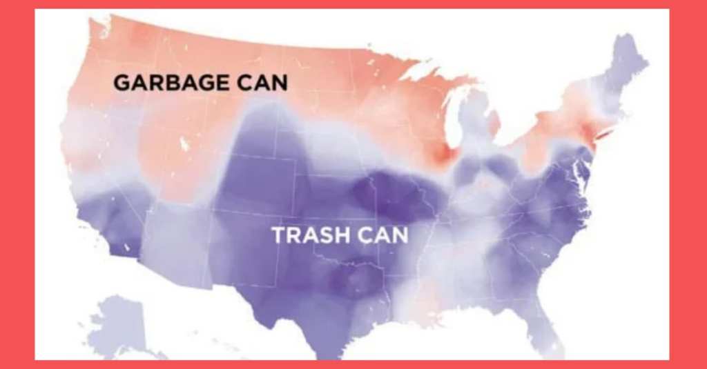
16. Who Says “Garbage Can” Vs. Who Says “Trash Can.”
We kind of say both, I think? Missouri is ever-divided.
Garbage Can v Trash Can in the United States
byu/AJgloe inMapPorn
15. Percentage of Foreign-Born Residents in Each State.
I love to see how our country is influenced by immigrants!
[deleted by user]
by inMapPorn
14. Portion of Each State that is Federal Land.
I had no idea there was so much, honestly.
13. States that Don’t Celebrate Columbus Day.
Why is this entire map not yellow?
Regions of the U.S. that don’t officially celebrate Christopher Columbus day
byu/dips9 inMapPorn
12. Counties with In N Out Burger.
How long until we can turn this whole map red?
All U.S. counties with In-N-Out Burger as of May 2020 [OC]
byu/AKWorld135 indataisbeautiful
11. Popular Coffee Shop Chains.
I’m low-key shocked that the whole map isn’t green.
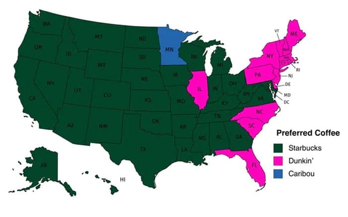
Image Credit: Reddit
10. Waffle House Locations Per State.
Some of these poor states have none!
9. The Lowest Recorded Temperature in Each State.
I’m moving where it’s warmer, yo.
Map of lowest recorded temperature in each US state (Fahrenheit) (OC)
byu/dannywat3rm3lon inMapPorn
8. Date of Creation By County
I love a good history map.
Date of Creation of All 3,142 U.S. Counties
byu/Bemily69 inMapPorn
7. Light Pollution in the United States.
If you want to see more stars, you know where to go.
Light Pollution in the United States [1604×818]
byu/there_is_no_try inMapPorn
6. U.S. Governors by Eye Color.
This is actually far more interesting than it looks at first glance.
5. Air Traffic Control Zones.
I thought there would be more!
Air traffic control zones in the USA
byu/lucyeeliza inMapPorn
4. Voters Who Didn’t Vote For Clinton or Trump in 2016.
This is the map that needs to change the most in 2020.
Voters who didn’t vote for Hillary or Trump
byu/ChemAnon2018 inMapPorn
3. U.S. Education Spending.
See where your state stacks up, and then call your reps!
2. Average Size of U.S. Apartments by Region.
Some people are living in really small spaces. I guess there’s less to clean.
Average Size of US Apartments by Region
byu/collectic inMaps
1. Map of Roads and Highways.
It’s so pretty when you look at it like this!
map of the United States’ 8 million miles of roads, streets and highways
byu/SkyHawk2112 inMapPorn
I’m completely enamored with all of these, and spent way too much time perusing them!
Which one was the most surprising or interesting to you? Let’s talk about it in the comments!


